Tag Archives: Malaysia Airlines

Malaysia Airlines considers a new name, brand and livery

Malaysia Airlines (Kuala Lumpur), owned by a majority share by a holding company of the Malaysian government, is considering changes in the the wake of the two tragic accidents this year.

According to RT.com, the government is considering a rebrand, a different ownership restructure, a possible new name and an adjustment of its route network.

Malaysia Airlines is very likely to change.

As far as the livery, the two ill-fated Boeing 777-200 ERs wore the older 1987 livery (above) which features the red and blue Kelantan Wau Bulan (Moon Dragon Kite) tail logo which has been seen in the headlines over and over, especially with the debris in eastern Ukraine. Any brand refresh would probably retire this iconic and historic logo.

Read the full article: CLICK HERE

Top Copyright Photo: Richard Vandervord/AirlinersGallery.com. Boeing 737-8FZ 9M-MLH (msn 31723) is pictured in action at Phuket, Thailand in the 1987 color scheme.

Malaysia Airlines:ย AG Slide Show

Below Copyright Photo: Ivan K. Nishimura/AirlinersGallery.com. Malaysia refreshed the red and blue Kelantan Wau Bulan (kite) livery in 2010 with this new twin arc look while retaining the kite tail logo. Boeing 737-8H6 9M-MSE (msn 40147) passes through Honolulu on delivery.

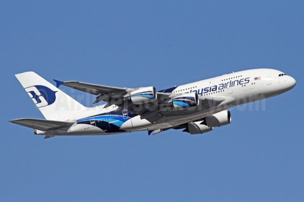
Below Copyright Photo: Michael B. Ing/AirlinersGallery.com. When Malaysia introduced the new Airbus A380, the airline unveiled this special A380 livery (for only the A380s) in 2012. The red and blue kite morphed into a blue kite for the A380s. Is this enough of a change? Probably not. Airbus A380-841 9M-MNB (msn 081) departs from London (Heathrow).

Bottom Copyright Photo: Christian Volpati/AirlinersGallery.com. When MSA was split into Malaysian Airline System (MAS) and Singapore Airlines, Malaysian (later Malaysia Airlines) originally introduced this livery in 1972. As you will note, the original livery featured a red and white kite tail logo. Dropping this historic logo will be a tough decision for the airline but unfortunately it is now a tarnished logo. Boeing 737-2H6 9M-MBH (msn 20926) prepares to depart from the gate at Kuala Lumpur.

Poll:


Can Malaysia Airlines survive two major air disasters?

Malaysia Airlines (Kuala Lumpur) is still in crisis mode after the savage downing of flight MH 17 over the Russian-speaking rebel-held area of the eastern Ukraine. The airline now avoids flying over the Ukraine.

Yesterday the flag carrier issued this statement about MH 17:

“Following the agreement Prime Minister Najib Razak brokered with rebel leaders, Malaysia has taken custody of flight MH 17’s black boxes. As the Prime Minister said, they will be passed to the international investigation team for analysis.

The international investigation team, led by the Netherlands, has decided to pass the black boxes to the UK Air Accidents Investigation Branch for forensic analysis. It is normal procedure for black boxes to be sent for analysis to the nearest laboratory authorized by the International Civil Aviation Association.

The black boxes will therefore be flown to Farnborough, UK, accompanied by Malaysian experts and other members of the international investigation team.”

Meanwhile on the financial side, the airline is also hurting. Load factors and yield are reportedly declining given the attention the airline is receiving in the media.

Previously on May 15 the airline reported a growing quarterly net loss of RM443 million ($139.5 million) for the three months ending on March 31, 2014 compared to a loss of RM279 million ($87.8 million) for the same quarter a year ago.

Bloomberg Businessweek is exploring the question of whether the airline can survive as we know it given this double tragedy and declining fortunes and cash flow.

According to the magazine, “MAS executives are focusing on finding a way to save the company. The carrier this week is going to present a plan to its parent, state-run Khazanah Nasional, Bloomberg News reported. Bankruptcy is one option. Taking the company private is another.”

Most likely the carrier will continue to operate in some form but it will probably change.

Read the full article: CLICK HERE

Copyright Photo: Karl Cornil/AirlinersGallery.com. Can Malaysia Airlines, with declining numbers, remain an Airbus A380 operator? The A380 is the flagship aircraft for the carrier but if it can’t fill the seats it may be the wrong aircraft for the airline. Airbus A380-841 9M-MNF (msn 114) arrives in London (Heathrow) with special “100th A380” markings.

Malaysia Airlines:ย AG Slide Show

The Dutch take over the crash investigation of shot-down Malaysia Airlines flight MH 17

Malaysia MH 17 Tail Debris (LRW)

The Dutch Safety Board has issued this statement:

The Dutch Safety Board took over formal responsibility for the air crash investigation from Ukraine yesterday evening (July 22). The two black boxes have since arrived in the United Kingdom, where they are currently being read out and analyzed by a team of international specialists. The on-site investigation in Ukraine is currently in full swing. Although investigators still do not have safe access to the crash site, work to gather and analyse data from various sources is underway in bothKiev and the Netherlands.

The first priorities will be to gather information from the crash site, analyse the black boxes and coordinate the international team. Ultimately, the air crash investigation should offer victims families and the international community a clear and comprehensive overview of the causes and course of the crash.

With the Dutch Safety Board now heading the investigation, the international investigation team will have more freedom to go about its tasks unhindered. The Dutch Safety Board is also responsible for coordinating all participating investigators and investigation teams from the countries involved (Ukraine, Malaysia, Australia, Germany, the United States, the United Kingdom and Russia) and the International Civil Aviation Organisation (ICAO). The international team currently consists of 24 investigators. A total of four Dutch Safety Board investigators are currently operating inUkraine.

Black boxes

On Tuesday evening (July 22) the two recorders arrived in Kiev from Kharkiv and were handed over to the Dutch Safety Board. They were then shipped by air to theUnited Kingdom, where an international team of specialists is working on the read-out and analysis of the data stored in the recorders. As a part of this effort, the team will also assess whether the black boxes may have been manipulated. The black boxes are expected to provide information relevant to this investigation. The analysis of black box data may take several weeks

On-site investigation

At the time of writing, the investigators have not yet been able to visit the site of the crash and conduct their investigation under safe conditions. In order to conduct an effective investigation, the investigators must have the opportunity to move around the entire investigation site freely, investigate materials and traces from up close and secure them for further study where necessary. At present, the investigators’ safety has not been guaranteed. The Dutch Safety Board and other parties involved are continually working to gain access to the accident site, and are working with other parties to organise effective security so that the investigators can do their work under controlled and safe conditions. Despite the fact that evidence and traces have been damaged or lost, the Dutch Safety Board expects it will be able to gather sufficient relevant information from the crash site.

Over the past few days, investigators have been working on the investigation in the Ukrainian capital of Kiev and in the Netherlands on the basis of available film and photo materials and other sources of information.

Investigation results

All information gathered as a part of this international investigation will be submitted to the Dutch Safety Board. The Dutch Safety Board will subsequently analyse this information, which will serve as the basis for a report and – where necessary – relevant recommendations. Other investigators or investigation boards will support this process and comment on the draft investigation report and its conclusions. The Dutch Safety Board will have the final say as regards the contents and timing of all publications. If the investigation shows evidence of any criminal or terrorist activities, the information will subsequently be submitted to the relevant authorities in accordance with applicable regulations. The Dutch Safety Board’s investigation will focus on ascertaining facts, rather than apportioning blame.

In addition to the international accident investigation, the Dutch Safety Board is also conducting two other independent investigations: an investigation into the decision-making process with regard to flight routes and an investigation into the availability of passenger lists. These investigation reports are expected to be published ahead of the main accident report.

Bloomberg Businessweek: International airlines are scrambling to do risk assessment of certain routes to ย now avoid conflict areas: CLICK HERE

Photo Credit: ANP. The tail section of downed 9M-MRD.

IATA makes a statement about Malaysia Airlines flight MH 17

IATA logo

The International Air Transport Association (IATA), representing the international airlines, has made the following statement of the shoot-down of Malaysia Airlines:

Statement of IATA’s Director General and CEO Tony Tyler:

“The tragedy of MH 17 is an outrage. Over the weekend it was confirmed that the passengers and crew aboard the aircraft were the victims of a hideous crime. It was also an attack against the air transport system which is an instrument of peace.

Among the immediate priorities, the bodies of the victims must be returned to their grieving loved ones in a respectful manner. For over four days we witnessed appalling sights from the crash scene. Governments must set aside their differences and treat the victims and their families with the dignity they deserve โ€“ and this includes urgently securing the site.

The investigation must also start quickly and with total freedom and access. Actions over the weekend which slowed down progress on both of these priorities were an outrage to human decency.

We have heard news of potential progress on both these issues. But promises now need to be turned into reality with actions.

Airlines and governments are partners in supporting global connectivity. Airlines carry the passengers and cargo. Governments and air navigation service providers inform airlines about the routes that they can fly and with what restrictions. Airlines comply with that guidance.

That was the case with MH 17. Malaysia Airlines was a clearly identified commercial jet. And it was shot downโ€”in complete violation of international laws, standards and conventionsโ€”while broadcasting its identity and presence on an open and busy air corridor at an altitude that was deemed to be safe.

No effort should be spared in ensuing that this outrage is not repeated. Of course, nobody should be shooting missiles at civilian aircraftโ€”governments or separatists. Governments will need to take the lead in reviewing how airspace risk assessments are made. And the industry will do all that it can to support governments, through ICAO, in the difficult work that lies ahead.

This was a terrible crime. But flying remains safe. And everyone involved in global air transport is fully dedicated to making it even safer.”

Where not to fly?

FAA logo

With the shoot down and crash of Malaysia Airlines flight MH 17 that was traveling at 33,000 feet over eastern Ukraine on a long range flight from Amsterdam to Kuala Lumpur, many international passengers are now wondering where not to fly when they travel on long range international flights. The amount of international conflict areas, i. e. war zones, is increasing. Of course, the introduction of sophisticated anti-aircraft weapons is now a major concern in some of these conflict areas.

Do you know where your flight is being routed, especially between Europe and Asia?

For guidance, the Federal Aviation Administration (FAA) has advised U. S. carriers to not fly in these dangerous areas. The Washington Post has produced this excellent map and report on the most dangerous overflight areas in the world.

Read the full report: CLICK HERE

International calls to secure the crash site of Malaysia Airlines flight MH 17 increase

The crash site of Malaysia Airlines (Kuala Lumpur) flight MH 17 with the pictured Boeing 777-2H6 ER 9M-MRD (msn 28411) in the Russian-speaking rebel-controlled part of eastern Ukraine remains largely unsecured. The world is calling for the crash site evidence to be properly secured.

From CNN:

“Bodies, backpacks, passports and other piles of debris lay splayed across a miles-long area in the remote area in eastern Ukraine where Malaysia Airlines Flight MH 17 came down. The crash site is massive — an international observer called it “one of the biggest crime scenes in the world right now.”

“Concern is growing that the site has not been sealed off as it should have been and that vital evidence is being tampered with. Meanwhile, armed rebels have greeted international observers with hostility.
Experts say that this crash investigation is unprecedented due to the site’s immense size and the lack of access given to investigators.”

Read the full report: CLICK HERE

Malaysia MH 17 Crash Site (Google Maps)

Google Maps above: The location of the crash site in the eastern Russian-speaking (disputed) portion of the Ukraine near Donetsk.

Malaysia MH 17 Heartfelt Message

Meanwhile Malaysia Airlines today issued these two statements (and the message above) on the tragic crash of flight MH 17:

The first statement – from theย Press Briefing by Liow Tiong Lai, Minister of Transport:

INTRODUCTORY STATEMENT

Today Malaysia Airlines have released the final list of nationalities on board flight MH 17. Each of the numbers represents a life lost, and a family in anguish. After this press conference, Malaysia Airlines will release the full passenger manifest.

Malaysia mourns the loss of all 298 passengers and crew. We feel for their families. And we promise to do all we can to ensure that the investigation is completed, and that justice is done.

ON THE INVESTIGATION:

Malaysia is deeply concerned that the crash site has not been properly secured. The integrity of the site has been compromised, and there are indications that vital evidence has not been preserved in place.

Interfering with the scene of the crash risks undermining the investigation itself. Any actions that prevent us from learning the truth about what happened to MH 17 cannot be tolerated. Failure to stop such interference would be a betrayal of the lives that were lost.

Malaysia calls for all parties to protect the integrity of the crash site, and to allow the investigation to proceed. We urge all those involved to respect the families, and the nations who have lost their sons and daughters in this attack.

Yes, MH 17 has become a geopolitical issue. But we must not forget that it is a human tragedy. Days after the plane went down, the remains of 298 people lie uncovered.

Citizens of eleven nations โ€“ none of whom are involved in the conflict in Eastern Ukraine โ€“cannot be laid to rest. Their lives were taken by violence; now violence stops them being accorded their final respect. This cannot continue.

ON DEPLOYMENT:

Earlier today, Malaysiaโ€™s special team arrived in Kiev. We ask for continued support from the Ukrainian government, and the other parties involved, as the team seeks to assist the Ukrainian authorities in recovering and identifying the remains of the passengers and crew, and with the wider investigation.

The world has a moral obligation to ensure that the remains of all victims are recovered and treated with respect. We will play our part in fulfilling this obligation. That is why, later today, I will join the Malaysian team in Kiev, where I will work with my counterpart in the Ukraine government, to support efforts to retrieve the remains, and to assist with the investigation.

I will be joined by the Director General of the Department of Civil Aviation, the Malaysian investigator in charge, and the Chairman of Malaysia Airlines. The CEO of Malaysia Airlines is already in Kiev.

ON THE FLIGHT PATH:

On the matter of MH 17โ€™s flight path, I would like to refer to recent reported comments by officials from Eurocontrol, the body which approves European flight paths under ICAO rules.

According to the Wall Street Journal, the officials stated that some 400 commercial flights, including 150 international flights crossed eastern Ukraine daily before the crash. Officials from Eurocontrol also stated that in the two days before the incident, 75 different airlines flew the same route as MH 17.

MH 17โ€™s flight path was a busy major airway, like a highway in the sky. It followed a route which was set out by the international aviation authorities, approved by Eurocontrol, and used by hundreds of other aircraft. It flew at an altitude set, and deemed safe, by the local air traffic control. And it never strayed into restricted airspace.

The flight and its operators followed the rules. But on the ground, the rules of war were broken. In an unacceptable act of aggression, it appears that MH 17 was shot down; its passengers and crew killed by a missile.

CONCLUDING REMARKS

This outrage cannot go unpunished. Once again, Malaysia condemns this brutal act of aggression, and calls for those responsible to be found, and to face the full force of justice without delay.

The second statement from Malaysia Airlines:

Malaysia Airlines is appealing to the family members or friends of those onboard MH 17 to contact the airline. Enclosed is the MH 17 passenger manifest for reference.

In the past 45 hours, the airline together with various foreign embassies have made every effort to establish contact with the next-of-kin but is still unable to identify many more family members.

They are advised to contact Malaysia Airlinesโ€™ Family Support Centre at +603 7884 1234 (in Malaysia).

Alternatively the family or friends may call the numbers below in their respective countries:

Netherlands (Malaysia Airlines Amsterdam office) +31 20 521 62 62

Australia (Malaysia Airlines Sydney office) +61 2 9364 3526

Indonesia (Malaysia Airlines Jakarta office) +62 2 1522 9705

New Zealand (Malaysia Airlines Auckland office) +64 9 306 3930

United Kingdom (Malaysia Airlines London office) +44 20 7341 2060

Germany (Malaysia Airlines Frankfurt office) +49 69 1387 1980

Philippines (Malaysia Airlines Manila office) + 63 2 889 1863

As of July 19, 2014, 5:00 pm, the table below shows the latest number of passengers and their nationalities:

Netherlands

193 (including 1 dual Netherlands/USA citizen)

Malaysia

43 (including 15 crew & 2 infants)

Australia

27

Indonesia

12 (including 1 infant)

United Kingdom

10 (including 1 dual UK/S. Africa citizen)

Germany

4

Belgium

4

Philippines

3

Canada

1

New Zealand

1

Total

298

Meanwhile, Malaysia Airlines deployed a ferry flight last night mobilizing 212 personnel from various government and media bodies and its staff to Kiev and Amsterdam in a special mission for MH17. A total of 85 Malaysia Airlinesโ€™ โ€˜Go Teamโ€™ members have been deployed, of which five members will join Malaysiaโ€™s Special Disaster Assistance and Rescue Team (Smart) in the search-and-recovery mission at the crash site in the Donetsk region, while 80 other members comprising care givers and the management team will be stationed in Amsterdam to assist the family members of the passengers.

MH 5002 departed Kuala Lumpur at 9.30 pm on July 18, 2014 and arrived in Kiev at 2.58 am (local time) on July 19, 2014 with a two hour transit. The aircraft then continued its journey to Amsterdam at 4.50 am (local time) on July 19, 2014 and arrived in Schipol Amsterdam Airport at 5.30 am the same day.

The mission is also joined by Malaysiaโ€™s Ministry of Transport, the National Security Council, Special Disaster Assistance and Rescue Team (Smart), Malaysiaโ€™s Department of Information, the Royal Malaysian Police, Malaysian Special Air Service, the Royal Malaysian Air Force, Malaysian Armed Forces, Department of Civil Aviation, Chemistry Department, Department of Islamic Advancement of Malaysia and the Disaster Victim Identification (DVI) team as well as participating media.

Finally, Malaysia Airlines requests the cooperation of members of the media to respect the privacy of the grieving families. The airlineโ€™s top priority remains to provide care and assistance to the families of the passengers and crew and any information with regards to their movement will not be made public.

Who are the pro-Russian rebels in eastern Ukraine? CNN takes a look at this question: CLICK HERE

Editorial Comment:

On a side note, it was fate that selected Malaysia Airlines to be the target for the Russian-speaking separatists in eastern Ukraine. According to U.S. intelligence, the rebels used recently delivered surface-to-air Russian missiles to bring down flight MH 17. Russia will have to answer for its decision to send these dangerous weapons to the Ukraine, a former part of the Soviet Union and a sovereign nation.

Why Eurocontrol was routing civilian airliners through this known war zone is something that will also have to be answered, especially after two Ukrainian aircraft were previously shot down by the pro-Russia forces in eastern Ukraine.

Air India and Singapore Airlines aircraft were also in the area at the time of the shoot down and it was fate that selected the Malaysia Airlines flight over these two flights. Fate has not been kind to Malaysia Airlines this year.

Bottom line: The remains of the ill-fated passengers need to be returned to their grieving families.

Where not to fly? The Washington Post has published this map of dangerous areas where the FAA has advised U.S. carriers not to fly: CLICK HERE

Copyright Photo: James Helbock/AirlinersGallery.com. 9M-MRD arrives in Los Angeles.

Malaysia Airlines:ย AG Slide Show

Malaysia Airlines flight MH 17 crashes in the Ukraine, all feared dead

Malaysia Airlines (Kuala Lumpur) flight MH 17 operating from Amsterdam to Kuala Lumpur with the pictured Boeing 777-2H6 ER 9M-MRD (msn 28411) (since repainted) with 280 passengers and 15 crew members, while operating at flight level 330 (33,000 feet) and about 50 nautical miles northwest of Donetsk, Ukraine has crashed. The airliner came down near the village of Shakhtarsk, Ukraine. Malaysia Airlines has confirmed the crash.

The airline issued this statement:

Malaysia Airlines confirms it received notification from Ukrainian ATC that it had lost contact with flight MH 17 at 1415 (GMT) at 30 km from Tamak waypoint, approximately 50 km from the Russia-Ukraine border.

Flight MH 17 operated on a Boeing 777 departed Amsterdam at 12.15 pm (Amsterdam local time) and was estimated to arrive at Kuala Lumpur International Airport at 6.10 am (Malaysia local time) the next day.

The flight was carrying 280 passengers and 15 crew members.

According to CNN:

“The aircraft was “shot down” over Ukraine by “terrorists” operating a Buk surface-to-air missile system, according to the Facebook page of Anton Gerashchenko, adviser to the Ukrainian Interior Ministry. There were 280 passengers killed as well as 15 crew members, Gerashchenko’s post reads.”

Read the full CNN report: CLICK HERE

Read the full updated account (with photos of the crash site) from the BBC: CLICK HERE

Read the report from the New York Times: CLICK HERE

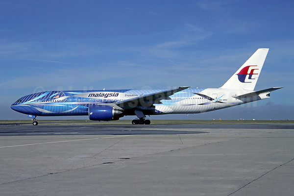
Top Copyright Photo: Christian Volpati/AirlinersGallery.com. 9M-MRD was once painted in this special “Blueย Heliconia” livery but it has since been repainted.

Malaysia Airlines Slide Show: CLICK HERE

Bottom Copyright Photo: Olivier Gregoire/AirlinersGallery.com. 9M-MRD lands in Paris (CDG) in 2011 after repainting.

More information will be added as details are confirmed.

Video:

Video: This video appears to capture the moment of impact:

Video: The Russian surface-to-air missile that is believed to have been fired and taken down the Triple Seven. The missile was allegedly fired from a Russian separatist controlled area in eastern Ukraine:

The ATSB announces a new search area for missing Malaysia Airlines flight MH 370

ATSB 6.26.14 Search Map for MH 370

The Australian Transport Safety Bureau (ATSB) today issued this summary and report announcing a new search area for Malaysia Airlines missing flight MH 370 operated with Boeing 777-2H6 ER 9M-MRO (msn 28420). Here is the summary (full report link at the bottom):

On March 8, 2014, flight MH 370, a Boeing 777-200 ER registered 9M-MRO, lost contact with Air Traffic Control during a transition of airspace between Malaysia and Vietnam. An analysis of radar data and subsequent satellite communication (SATCOM) system signalling messages placed the aircraft in the Australian search and rescue zone on an arc in the southern part of the Indian Ocean. This arc was considered to be the location where the aircraftโ€™s fuel was exhausted.

A surface search of probable impact areas along this arc, coordinated by the Australian Maritime Safety Authority, was carried out from 18 March โ€“ April 28, 2014. This search effort was undertaken by an international fleet of aircraft and ships with the search areas over this time progressing generally from an initial southwest location along the arc in a north-easterly direction. The location of the search areas was guided by continuing and innovative analysis by a Joint Investigation Team of the flight and satellite-communications data. This analysis was supplemented by other information provided to ATSB during this period. This included possible underwater locator beacon and hydrophone acoustic detections.

No debris associated with 9M-MRO was identified either from the surface search, acoustic search or from the ocean floor search in the vicinity of the acoustic detections. The ocean floor search was completed on May 28, 2014.

Refinements to the analysis of both the flight and satellite data have been continuous since the loss of MH 370. The analysis has been undertaken by an international team of specialists from the UK, US and Australia working both independently and collaboratively. Other information regarding the performance and operation of the aircraft has also been taken into consideration in the analysis.

Using current analyses, the team has been able to reach a consensus in identifying a priority underwater search area for the next phase of the search.

The priority area of approximately 60,000 km2 extends along the arc for 650 km in a northeast direction from Broken Ridge. The width of the priority search area is 93 km. This area was the subject of the surface search from Day 21-26.

Work is continuing with refinements in the analysis of the satellite communications data. Small frequency variations can significantly affect the derived flight path. This ongoing work may result in changes to the prioritisation and locale of search activity.

Read the full report: CLICK HERE

The “7th Arc”

You will hear a lot about this term in the coming days. Here is the explanation:

The latest information and analysis confirms that MH 370 will be found in close proximity to the arc set out in the map and labelled as the 7th arc. At the time MH 370 reached this arc, the aircraft is considered to have exhausted its fuel and to have been descending. As a result, the aircraft is unlikely to be more than 20 NM (38 km) to the west or 30 NM (55 km) to the east of the arc.

Based on all the independent analysis of satellite communications and aircraft performance, the total extent of the 7th arc reaches from latitude 20 degrees S to 39 degrees S.

Refinement of the analysis in the coming weeks will reduce the underwater Search Area along this arc to a prioritised 17,500 sq. NM (60,000 sq. km). The prioritised length of the Search Area along the arc is expected to be 350 NM (650 km).
More information about the Search Area will be made available as soon as it is verified.

Map of the “7th Arc”:

ATSB 7th Arc Map


The search for missing Malaysia Airlines flight MH 370 is likely to move south

ATSB logo

Malaysia Airlines (Kuala Lumpur) missing flight MH 370 of March 8 with 239 passengers and crew members on board remains missing. The next phase of the search is likely to move the search area several hundred miles to the south in the southern Indian Ocean.

The Associated Press first reported this change, citing Martin Dolan, chief commissioner of the Australian Transport Safety Bureau (ATSB).

The Bluefin-21 will be redeployed in this new area. The exact new area is still being determined.

On May 26 Martin Dolan issued this statement about the search:

By Martin Dolan, Chief Commissioner

Itโ€™s now been more than 11 weeks since Malaysia Airlines flight MH 370 disappeared from air traffic control radar after taking off from Kuala Lumpur on a scheduled passenger service to Beijing.

Despite one of the most intensive and coordinated air and sea search efforts ever undertaken, there has not yet been any sign of the missing aircraft.

The complexities surrounding the search cannot be understated. It involves vast areas of the Indian Ocean with only limited known data and aircraft flight information. While it is impossible to determine with certainty where the aircraft may have entered the water, all the available data indicates a highly probable search area close to a long but narrow arc of the southern Indian Ocean.

It is now highly unlikely that surface debris from the aircraft will be spotted. This means that the most effective way to continue the search is to look for MH370 under the water.

The search will be a major undertaking.

The complexities and challenges involved are immense, but not impossible.

Following an announcement by the Prime Minister of Australia in late April, and at the request of the Malaysian government, the ATSB is planning an intensified underwater search of a 60,000 square kilometre areaโ€”roughly the size of Tasmania.

As part of its search operations, the ATSBโ€™s initial work involves:

reviewing existing information, from an expert satellite working group, to refine a search zone of up to 60,000 square kilometres in the southern Indian Ocean
conducting a bathymetric survey to map the search area
consulting with domestic and international authoritiesโ€”including various oceanographic institutions and private companiesโ€”to prepare the plan and specialist services required for the next search phase.
The bathymetric surveyโ€” or mapping of the ocean floorโ€” has already commenced, with the Chinese survey ship Zhu Kezhen conducting a survey of the areas provided by the ATSB. Zhu Kezhen will shortly be joined by a contracted commercial survey vessel in June. Taking around three months to complete, the bathymetric survey will give us crucial knowledge of the seafloor terrain needed to begin the underwater search.

The intensified underwater search will aim to locate the aircraft and any evidence (such as aircraft debris and flight recorders) to assist with the Malaysian investigation. The equipment used for the search will likely include a towed sonar, an Autonomous Underwater Vehicle with mounted sonar, and optical imaging equipment. We expect the search to begin in several months and take up to 12 months to complete.

The search will be a major undertaking. The complexities and challenges involved are immense, but not impossible. The best minds from around the world have been reviewing, refining and localising the most likely area where the aircraft entered the water, which is why we remain confident of finding the aircraft.

On May 26 the ATSB issued this detailed statement on the considerations of where it will search for MH 370:

Background

At the request of the Malaysian Government, Australia is leading the search for missing Malaysia Airlines Flight MH 370 in the Indian Ocean. The search is a complex operation that involves vast areas with only limited data and aircraft flight information available.

Over-water searches

Over-water aircraft accident locations are usually found by conducting a broad-area aerial search. The search area is generally determined by a combination of:
Position information from ground-based radar systems (maximum range is generally 250 NM)
Position information automatically transmitted from the aircraft at regular intervals

Position reports from the crew

Re-tracing the planned flight route

Eye-witness reports (possibly located on the shore, on other aircraft or on ships)

Uncertainty in the position of an accident location increases with time from the aircraftโ€™s last known position (fix) so the search area will expand accordingly as the position data becomes โ€˜staleโ€™.

Once floating wreckage is observed, reverse-drift techniques can be used to help determine the aircraft impact location. Only a small-area underwater search is then required to locate the wreckage and map the wreckage field. This underwater search can be aided by the underwater locator beacons fitted to flight recorders. As the beacons have a limited duration of nominally 30 days and to minimise the inaccuracies of the reverse-drift calculations, it is important that an aerial search is commenced as soon as possible and the floating debris is found quickly.

In the case of MH 370:

The aircraft departed Kuala Lumpur at 1641 UTC
The final automatically transmitted position from the aircraft occurred at 17:07 UTC
No radio communications were received from the crew after 17:19 UTC
The final ATC (secondary) radar fix occurred at 17:22 UTC
At 17:25 UTC the aircraft deviated from the planned flight route
The final primary radar fix occurred at 18:22 UTC
The satellite communications log indicated the aircraft continued to fly for another 6 hours
No confirmed eye-witness reports were received
The search in the Australian search and rescue zone commenced on 18 March (10 days after the aircraft went missing)

As a result, the search area for MH 370 has remained very large. A useful comparison is the search for Air France Flight 447 (AF 477), which crashed in the Atlantic Ocean on 1 June 2009. The AF447 aircraft was programmed to send its position automatically every 10 minutes, there were a number of fault messages transmitted via satellite during the last few minutes of flight and it was following the planned flight route. The search for the aircraft began on 1 June and the first surface wreckage was discovered on 6 June, 5 days after the accident. Given the relative accuracy of the aircraftโ€™s last known position, a circular search area of 40 NM was defined (17,240 kmยฒ). After a search effort involving five separate phases, the aircraft wreckage was located on the ocean floor almost two years later.

As none of the traditional sources of data could be used to locate the aircraft wreckage from MH 370, it has been necessary to use novel sources of data and analysis techniques. This has led to a larger than typical search area; and there have been changes to its location as validation and calibration checks have been performed and the analysis is refined.

Determining the search area for MH 370

The flight path of MH 370 has three distinct sections; one under secondary radar in which the aircraft transponder was operational and ACARS messages were being transmitted, a primary radar section during which the aircraft was being tracked solely by air defence radar systems and the final stage for which the only information available was the satellite communications log data.

ACARS and radar data

The final ACARS transmission was at 17:07 UTC and provided location reports from the initial stage of the flight as well as a recording of the aircraft fuel remaining. The final secondary radar point was at approximately 17:22 UTC. The final primary radar point was at 18:22 UTC. Figure 1 shows the first and second sections of the flight.

Figure 1: MH 370 Flight path derived from Primary and Secondary radar data:

MH 370 Figure 1

Source: NTSB/Google

Satellite communications (SATCOM) data

Following the loss of primary radar, the only available information was from satellite signalling messages, also referred to as โ€˜handshakesโ€™, between the ground station, the satellite and the aircraftโ€™s satellite communication system.

For each transmission to the aircraft, the ground station recorded the burst timing offset (BTO) and the burst frequency offset (BFO).

Figure 2: Satellite communications schematic:

MH 370 Figure 2

Source: Inmarsat

Burst Timing Offset (BTO)

The BTO is a measure of the time taken for a transmission round trip (ground station to satellite to aircraft and back) and allows a calculation of the distance between the satellite and the aircraft. Based on this measure, a possible location ring can be mapped on the surface of the earth (Figure 3). An analysis of SATCOM system parameters showed that the accuracy of the rings was ยฑ 10 km. This analysis was validated using recorded BTO values from the initial stage of the flight when the aircraftโ€™s position was known.

Figure 3: Satellite ring derivation:

MH 370 Figure 3

Source: Inmarsat

There were 7 handshakes between the ground station and the aircraft after the loss of primary radar data. The location rings calculated from the recorded BTO values are shown in figure 4.

Figure 4: MH 370 timing (UTC) with corresponding rings arrowed:

MH 370 Figure 4

Source: Inmarsat/Boeing /Google

The information from the BTO places the aircraft somewhere on each ring at the corresponding time. By taking the maximum speed of the aircraft into account, the rings can be reduced in length to arcs โ€“ there are some areas of the rings it simply could not have reached.

Burst Frequency Offset (BFO)

The BFO is the measure of the difference between the expected frequency of the transmission and the frequency received at the ground station. This difference is attributed to various sources including the Doppler Effect from the motion of the satellite and the aircraft, as well as some processing effects. Once the known components that contribute to the BFO are resolved, the remainder can be used to estimate the speed and direction of the aircraft. There are a large number of speeds and headings that can be consistent with a BFO recording. These are limited, however, by the operational constraints of the aircraft.

Candidate paths of different speeds were created which met the BTO ring location/time constraints and the predicted BFO values of these paths have been compared with the recorded values. The better the match, the higher the probability that the path was close to that of MH370.
Final handshake message at 00:19 (7th arc)

The 00:19 signalling message (7th arc) was a logon request from the aircraft. This is consistent with the satellite communication equipment on the aircraft powering up following a power interruption. The interruption in electrical supply may have been caused by fuel exhaustion.

Note on the satellite communication

The satelliteโ€™s normal function is essentially communication and it was never initially intended to have the capability to track an aircraft. Following the Air France 447 accident, Inmarsat engineers began recording the BTO in order to provide another potential means of geo-locating aircraft in the event of a similar accident.

Aircraft Performance Calculations

Estimates of fuel consumption were calculated from the time of the last recorded fuel quantity, using a range of flight paths and speeds. The results of these calculations were consistent with fuel exhaustion occurring close to the 7th arc.

Validation

Several teams independently provided both satellite communications and performance analysis as part of the validation process. The location of 9M-MRO on previous flights as well as the locations of other aircraft in the air at the same time were all used to validate the techniques.

Other information

Surface search

An international air and maritime force conducted a surface search of drifted regions along the 7th arc from 18 March to 28 April 2014. A drifted region is created by modelling the movement of an area of water over the time period when the surface search is conducted. During this time, no debris was identified to be likely from MH 370.

Underwater search

Acoustic detections possibly related to underwater locator beacons were made by two vessels in the refined probability area from 5 – 8 April 2014. To further investigate these signals, a search of the ocean floor around the detections was performed by a number of vessels. To date no further sign of MH370 has been detected.

Hydrophones

Low frequency hydroacoustic signals present in the Indian Ocean are being examined to determine whether they can provide any information to help define the search area. These signals are recorded by hydrophones as part of the United Nations Comprehensive Nuclear-Test-Ban-Treaty Organisation (CTBTO) or the Integrated Marine Observing System (IMOS).

Use of waypoints

Comparison of possible flight paths with tracks using waypoints is also under consideration.

Air Routes

There is only one published north-south air route in the south-eastern Indian Ocean. Air route M641 connects Cocos Island to Perth and has four waypoints. The air route crosses the area where the four acoustic signals were detected.

Shape of the search area

At the time MH 370 reached the 7th arc, the aircraft is considered to have been descending. A study completed after the Air France 447 accident concluded that the majority of aircraft in loss of control accidents were found within 20 nautical miles (32 km) of their last known position. This provides a reasonable limitation for the size of the search area across the arc.

Additionally the Australian government through the ATSB on May 26 explained how it is searching for missing flight MH 370:

Background

The Australian Transport Safety Bureau (ATSB) is leading the underwater search for missing Malaysia Airlines flight MH 370. All the available data indicates the aircraft entered the sea close to a long but narrow arc of the southern Indian Ocean.

The search is a complex operation that will involve a range of vessels, equipment and expertise to cover 60,000 square kilometres of ocean floor.

Bathymetric survey

During the first stage of the search, the ATSB is tasking a Chinese PLA-Navy ship to undertake a bathymetric survey of the 60,000 square kilometre search area. A contracted commercial vessel with join the survey in June. The bathymetric survey will provide a map of the underwater search zone, charting the contours, depths and hardness of the ocean floor.

While the ocean depth of the search zone is understood to be between 1000 m and 6000 m, we currently have very limited knowledge of the sea floor terrain facing the underwater search operation. The information we receive from the bathymetric survey will give us crucial data to plan and conduct the intensified underwater search.

How the surveyโ€™s done

The operation will involve a ship surveying the ocean floor using multi beam sonar, which is capable of collecting high quality data to water depths of up to 6,000 m.

Multibeam sonar is a common offshore surveying tool that uses multiple sound signals to detect the seafloor. Due to its multiple beams it is able to map a swath of the seabed under the ship, in contrast to a single beam sonar which only maps a point below the ship. Different frequencies are used to map different water depths, with higher frequencies (>100kHz) used for shallow water and low frequencies (<30 kHz) for deep water.

Generally, the multibeam sonar transducer is mounted rigidly to the hull of the survey vessel and its position can be calculated very accurately. Other parts of the multibeam system include auxiliary sensors such as motion-sensing systems and Global Positioning Systems (GPS) to ensure accurate positioning, motion sensing and sound speed measurement system.

A modern multibeam sonar transducer typically uses the Mills Cross telescope array. The sound is transmitted from transducers that are perpendicular to the survey track. Consequently, the sound pulses forms a transmit swath that is wide across-track and narrow along-track. The returning sound pulses, which are mainly recording the impedance contrast and seafloor topography, are received by the receivers which are mounted parallel to the survey track. These return beams are narrow across-track.

Unlike the sidescan sonar which commonly produces only acoustic backscatter data (i.e. hardness), the multibeam sonar generates both water depth and seafloor hardness data concurrently.1
How many vessels will be involved in the survey

The Chinese PLA-Navy ship Zhu Kezhen (872) is already in the search area conducting a bathymetric survey of an area provided by the ATSB. A contracted survey vessel will arrive in the search area in early June.

How long it will take?

It is expected that the bathymetric survey will take around three months to complete, but this will depend on a number of factors, such as weather conditions, during the survey operations.
The underwater search will begin when we have enough data from the bathymetric survey to start searching. This means that the underwater search will begin while the survey is still being completed.

On June 4 the ATSB issued a request for specialist help in determining the new search area (all proposals are due by June 30):

The ATSB has released a request for tender to acquire the services of a specialist company capable of conducting a deep-water search under ATSB direction for missing Malaysia Airlines Flight MH 370.
Engaged as a prime contractor, the company will provide the expertise, equipment and vessel(s) necessary to undertake an intensified underwater search for the missing Boeing 777 aircraft in the defined zone in the southern Indian Ocean.

While the precise search zone is currently being established by an international search strategy working group, it is expected that the successful tenderer will search an area up to 60,000 square kilometres based on the ‘seventh handshake’ arc where the aircraft last communicated with the Inmarsat satellite. Definition of the search zone will be finalised within two to three weeks.

The successful tenderer will localise, positively identify and map the debris field of MH 370 using specialist equipment such as towed and autonomous underwater vehicles with mounted sonar and/or optical imaging systems.

The intensified search will begin in August 2014 and is expected to take up to 12 months, depending on weather conditions. The successful tenderer will use the data from a bathymetric survey (already underway) to navigate the search zone, which has water depth between 1000 and 6000 metres.

The search vessel(s) used by the prime contractor may also be coordinated with other vessels also undertaking search activities in the search zone on behalf of other countries.

A copy of the request for tender is available on the AusTender website at http://www.tenders.gov.au. Request for tender submissions are due by 5.30pm AEST on June 30, 2014.

At the request of the Malaysian Government, the ATSB is leading the search for missing Malaysia Airlines Flight MH370.

Search for MH 370 Facts and Statistics:

Joint Agency Coordination Centre of Australia has issued these statistics on the search for MH 370:

Search for MH 370 facts and statistics

  • ๏‚ท ย Prime Minister Tony Abbott advised of the establishment of the JACC on 30 March 2014, headed by Air Chief Marshal Angus Houston AC AFC (Retโ€™d).
  • ๏‚ท ย Malaysia has lead investigative responsibility and the international accident crash investigation is based out of Kuala Lumpur.
  • ๏‚ท ย Malaysia, the United States of America, the United Kingdom, China, the Republic of Korea, Japan, New Zealand and Australia were all involved in the visual search.
  • ๏‚ท ย Over 4,600,000 square kilometres of ocean surface were searched.
  • ๏‚ท ย 345 search sorties were conducted by military aircraft for a total of over 2,998 hours.
  • ๏‚ท ย Over 30% of the military flights were made by Royal Australian Air Force planes.
  • ๏‚ท ย Aircraft that were involved in the visual search included:
    • – ย 8 x Royal Australian Air Force ( 4 x AP-3C Orion, 2 x E-7A Wedgetail, 1 x KA350 King Air, 1 x C-130J Hercules)
    • – ย 1 x Royal New Zealand Air Force (P-3K2 Orion)
    • – ย 2 X United States Navy (P-8A Poseidon)
    • – ย 2 x Peoples Liberation Army Air Force (IL โ€“ 76)
    • – ย 3 x Japan (2 x Japanese Maritime Self Defense Force P-3C Orion and 1 x Japanese Coast GuardGulfstream V)
    • – ย 2 x Republic of Korea (1 x ROK Navy P-3C Orion & 1 x ROK Air Force C-130H)
    • – ย 3 x Royal Malaysian Air Force (3 x C-130H Hercules)
  • ๏‚ท ย Over 25 million litres of aviation fuel was used during the course of the visual search.
  • ๏‚ท ย Up to 19 ships were used to cover the search area.
    • – ย 5 x Australian ships (1 x Replenishment Ship – HMAS Success, 1 x Frigate – HMAS Toowoomba including 1 x Seahawk Helicopter, 1 x Frigate – HMAS Perth, 1 x Australian Defence Vessel – Ocean Shield, 1 x Motor Vessel – Seahorse Standard)
    • – ย 1 x USA ship (1 x Replenishment Ship – USNS Cesar Chavez)
    • – ย 2 x UK ships (1 x Survey Ship – HMS Echo and 1 x Submarine – HMS Tireless)
    • – ย 10 x Chinese ships (1 x Destroyer โ€“ Haikou, 2 x Amphibious Landing Dock – Kunlunshan & Jinggangshan, 1 x Coast Guard Vessel – Haixun 01, 2 x Ocean going Rescue Vessel – Donghaijui 101 & Nan Hai Jiu 101, 1 x Ocean going Rescue Vessel – Ben Hai Jiu III Wars 115, 1 x Replenishment Ship – Quindao Hu, 1 x Ice Breaker – MV Xue Long including Chinese Helicopter 7102, 1 x Survey Ship – Zhu Kezhen)
    • – ย 2 x Malaysian ships (1 x Frigate – Lekiu 30, 1 x Replenishment Ship – Bunga Mas Enam BM-6)
  • ๏‚ท ย Bluefin-21 conducted a sub-surface search of over 850 square kilometres of the ocean floor.


CNN: How long will the search for MH 370 continue?

Malaysia logo-1

Malaysia Airlines’ (Kuala Lumpur) missing flight MH 370 has now been missing for 100 days. So far, no debris from the missing fine has been found. Nothing has been found, despite promising leads and observations. Everything turned out to be floating ocean flotsam.

The previously reported “pings” are now thought to be erroneous. In short, missing flight MH 370 is a true aviation mystery of epic proportions.

Missing Air France flight AF 447 took almost two years to be located so there is some hope MH 370 will be found. However authorities had a better idea where AF 447 was located. For the MH 370 without better data, no one knows for sure where the flight is located. For the families of the missing passengers and crew members, this uncertainty is so hurtful and very hard to accept. They cannot have any closure. The families rely on any hope which they cling to. Today, after 100 days, they have very little to cling to.

CNN has raised the difficult question of how long the search will continue. The search is very costly and without better data it has a low chance of being discovered. If anyone wanted to have this flight “disappear” they have succeeded.

So far Australia has shouldered most of the cost in the search. Australia is leading the search due to assumption the flight crashed into the southern Indian Ocean closest to Australia. Many other countries including the United States, Malaysia and China have contributed costly assets and crews in the search with zero results. The assumption that the flight crashed near Australia is now in question. In short, no one knows where MH 370 has gone.

Read the full report: CLICK HERE